
Sunset on the salt flats
(In the first week of October, 2014, I set out to hike the Lowest to Highest Route with NotaChance and Orbit. This is the second installment of my trip report. For technical information on this route, go here.)
——————
October 2
6 miles
“Fuck! Fuck! Fuck!” I’m down on my hands and knees on the salt flats, blood running everywhere. I try to push myself up but it’s hard- the salt is really sharp, and my hands are bleeding. My face is cut up too, and my knee. “Fuck!” I say again. I’m crying. We’ve been walking for about three miles, in the dark, without headlamps- the moon is big and bright like a streetlamp so we haven’t needed them- everything is illuminated. When I imagined this trip, I always imagined that this first six miles, walking on the salt flats, would be the easy part. I imagined the salt flats as a smooth, sandy place where we’d plod along in a general sort of direction. I figured we’d make great time. But it turns out that the salty mud, just like everything here, is shaped by the flash floods that periodically move through, and the stuff dries in all sorts of crazy, fantastical ways- big geometrical chunks, sticking up like water-swollen puzzle pieces, thin tinkling crusts through which one post-holes with a sound like shattering glass, and pointy, irregular lumps that glitter in the moonlight and, it turns out, are really, really sharp. The going has been slower than I’d imagined and then, like a fool, I tripped and fell on my face.
Jess and Chance appear (we’d been walking spread out across the salt flat, lost in our own thoughts, following the tinkling sounds of each others’ progress) and Chance pulls the foam pad out of my backpack so that I have something to sit on. I wipe at my face- I fell pretty hard on my face but my nose is not, as I thought it might be, broken, and most of the stuff on my face is dirt, not blood. Jess shines a light on my knee, and there’s the source of most of the blood- there seems to be a hole punched there, in the soft part just below the kneecap, into what I can only describe as “bacon fat”. There’s a small, yellow piece hanging loose, and as I stare at it the blood slows to a trickle. There isn’t any pain- my face and torn-up hands are what hurt the worst. Must not be very many nerve endings there- a sort of natural knee pad. That’s cool. I poor some water on the hole to wash out the grit.
“That wound is badass,” says Jess. This cheers me up. Chance tells me about the time she rode an office chair down a really steep hill to impress someone, and the wounds she sustained from that.
“Do you think it needs stitches?” I say.
“Nah,” says Chance. I wonder what I should do. We’re only three miles in, and the hole in my knee is pretty deep. Of course none of us carry first-aid kits. If I limped back to the boardwalk right now, leaving Jess and Chance to do the hike without me, no-one would fault me. It would make perfect sense- I had to get stitches! Life is full of these moments, I think. These perfect little opportunities to quit. Sometimes quitting is the most reasonable thing. And yet, if I’ve learned anything, it’s to see these moments as red flags. These moments, more than anything, are the moments when you’ve got to keep going.
I fish out some hand sanitizer and squirt it into the wound. It doesn’t even burn.
“Seems fine,” I say.
We make it to the jeep road on the other side of the salt flats at 10 p.m., and poke around for a place to camp. We’re exhausted but we’re wired too, high on the uncertainty of this adventure, the feeling that anything can happen. We unfurl our bedrolls beneath the moon and I rinse out the hole in my knee again, pour some more hand sanitizer in there. I’ve got a clean bandanna and I tie it over my knee. That oughta do ‘er. Who needs first aid kits when you have hand sanitizer and a clean bandanna?
It’s warm, too warm for my sleeping bag, and there are these little gnats everywhere, swarming my face, crawling in my nose like they want to eat the moisture there. The moon is practically pulsating in the sky, suspended above the salt flats, casting everything in shadow. Our alarm is set for 5 a.m.- we want to get in as much hiking as we can before the heat hits. Tomorrow we climb up towards Telescope Peak, an ascent of ten thousand feet in fourteen miles. It’s the fourth steepest climb in the U.S. And there isn’t any trail. We’ll also locate our first desert water source.
I know I should be asleep, but I feel so awake. My whole body is humming with energy. What’s going to happen, and what will it even be like?
Life is really, really good.
—————————
October 3
23 miles
Jess hands around her jetboil of hot water and there’s a little instant coffee for everyone- I pull the blood-crusted hanky off my knee, fold it carefully for re-use and then we’re up, working our way towards Hanaupah canyon as the horizon transitions to orange, aquamarine, and then the sun shoots crystal magic light-rays over the crest of the mountains, illuminating the whole clear pure universe.
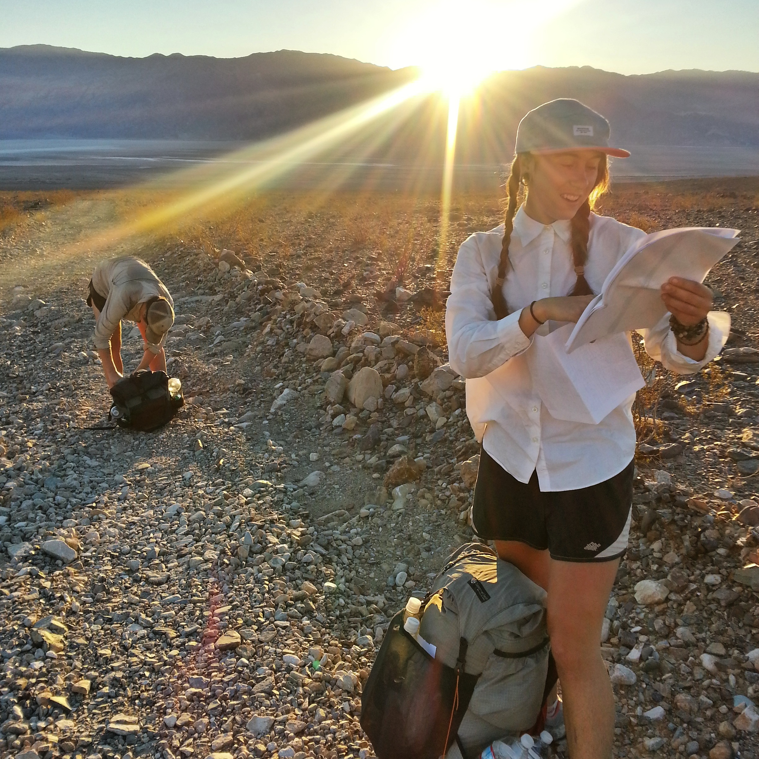
Jess/Maps/Sunrise/Chance
.

Failed morning group selfie w/Jess’ eye and Chance’s hat
Hanaupah spring is a miracle- one moment the world is a conflagration of salt and rocks and dust and light and then there’s the sound of running water, real bubbling water, and tall straight green water plants and a spring, flowing just casually, and just as casually going underground not soon after. I cup the water and pour it over my head, soak my shirt in it. We can see that the source is further up the canyon- there’s a whole swatch of green there, in the shaded crooks and gulleys, verdant and impossible. Also a little cave in the face of the hill- where a miner once lived? We sit in a hunk of shade next to a big rock and laugh, and eat food, and consume more caffeine. Caffeine. We are going to need lots of caffeine on this trip.
After resting we do as Charlie said and begin the long slog up towards the ridge. It’s slow going, just like everything we’ve done so far. All my hiking experience is on the PCT and I’m learning that, compared to this, the PCT is like running a marathon with aid stations- the path is gently graded and generally free of obstacles, and resupply points are a reasonable distance apart. All you have to do, then, on the PCT, is concentrate on walking as fast as you can. Hiking cross-country is a whole different animal- the ground is uneven, and there are almost always things in the way. And while I can space out on the PCT, hiking without a trail keeps my brain almost constantly engaged- I’m thinking about where I am in reference to the landscape around me, what the landscape is about to do and how, exactly, I am going to get to where I need to go. And there’s the thought that goes into my footwork- stepping up and around and over and veering here and there and looking for faint animal trails and pausing and recalculating and backtracking a few steps and looking to see where Chance and Jess are, and if they’ve found a better route, and wondering if the slope is gradual enough or if it’s about to get too steep and I’m going to have to climb hand over hand and maybe I should go over there, to that other slope, maybe that would be the more efficient way? It feels like I’m doing a crossword puzzle while I hike and I love it- it’s a sort of intimacy with the landscape that I’ve never experienced before. Badwater Basin, Hanaupah Canyon, Telescope Ridge- these places are being burned into my memory, I’m feeling them meter by meter with my hands, their topography is being lovingly cataloged by some part of my brain that I’ve never even USED before. I’m an animal, I’m a deer, I’m a free wild creature, and I’m just casually moving over the land!

Jess and Chance on the climb out of Hanaupah Canyon
.
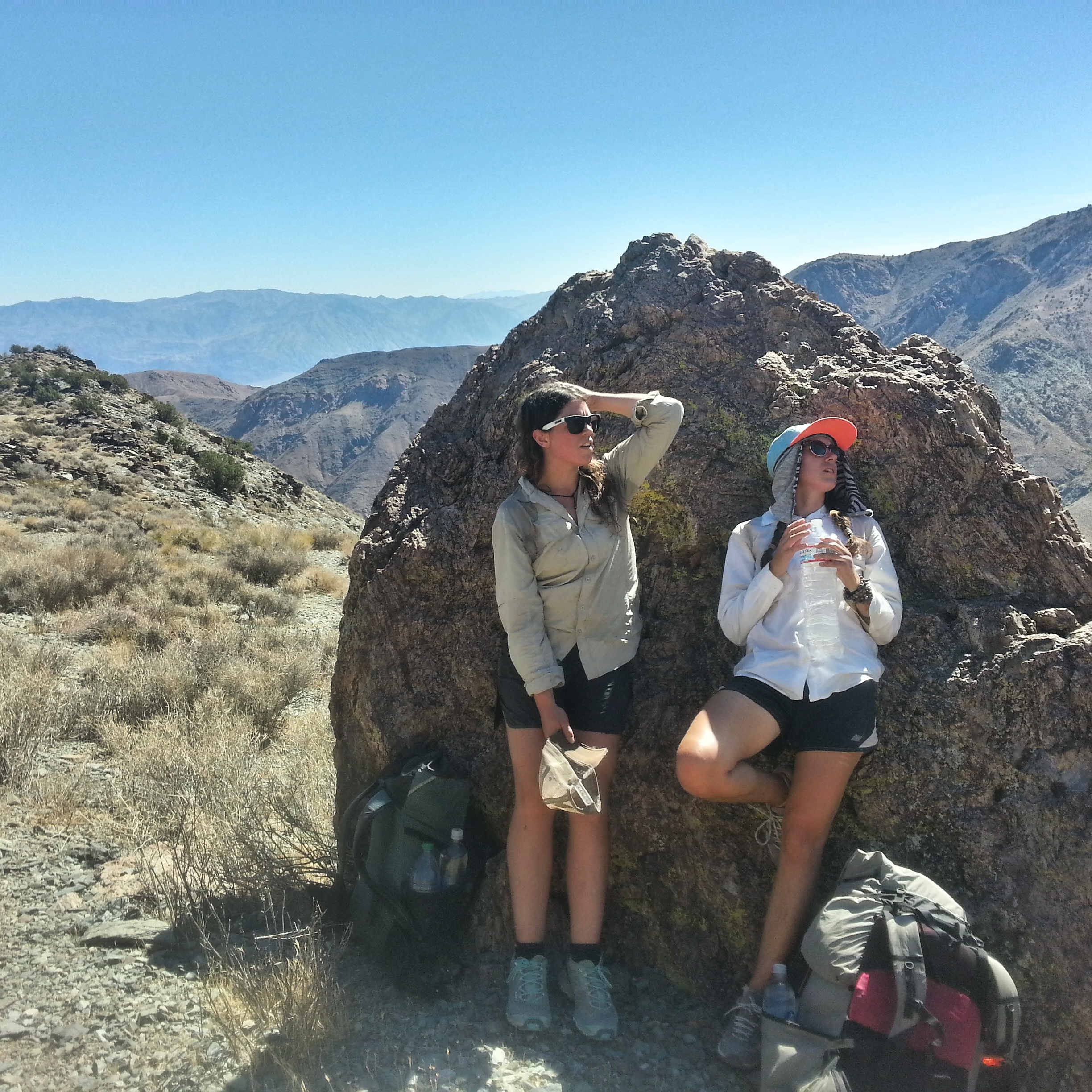
Breaktime on the climb
The climb is straight up, and it is STEEP. Endorphins are dumping into my body at an unprecedented rate and the air is cooling as we gain elevation, soon we’re in shady pinyon forest and I feel happier than I have in weeks, mashing uphill at one mile an hour, my achilles tendons so tight they feel like they might snap. Go legs, go! This is what I live for! Long steep climbs, I never thought I would learn to love them. When I first started hiking I dreaded the climbs. But the endorphins of steep climbs are a thing without parallel, and that feeling you get upon reaching the top is a feeling, I am learning, to build one’s entire life around.
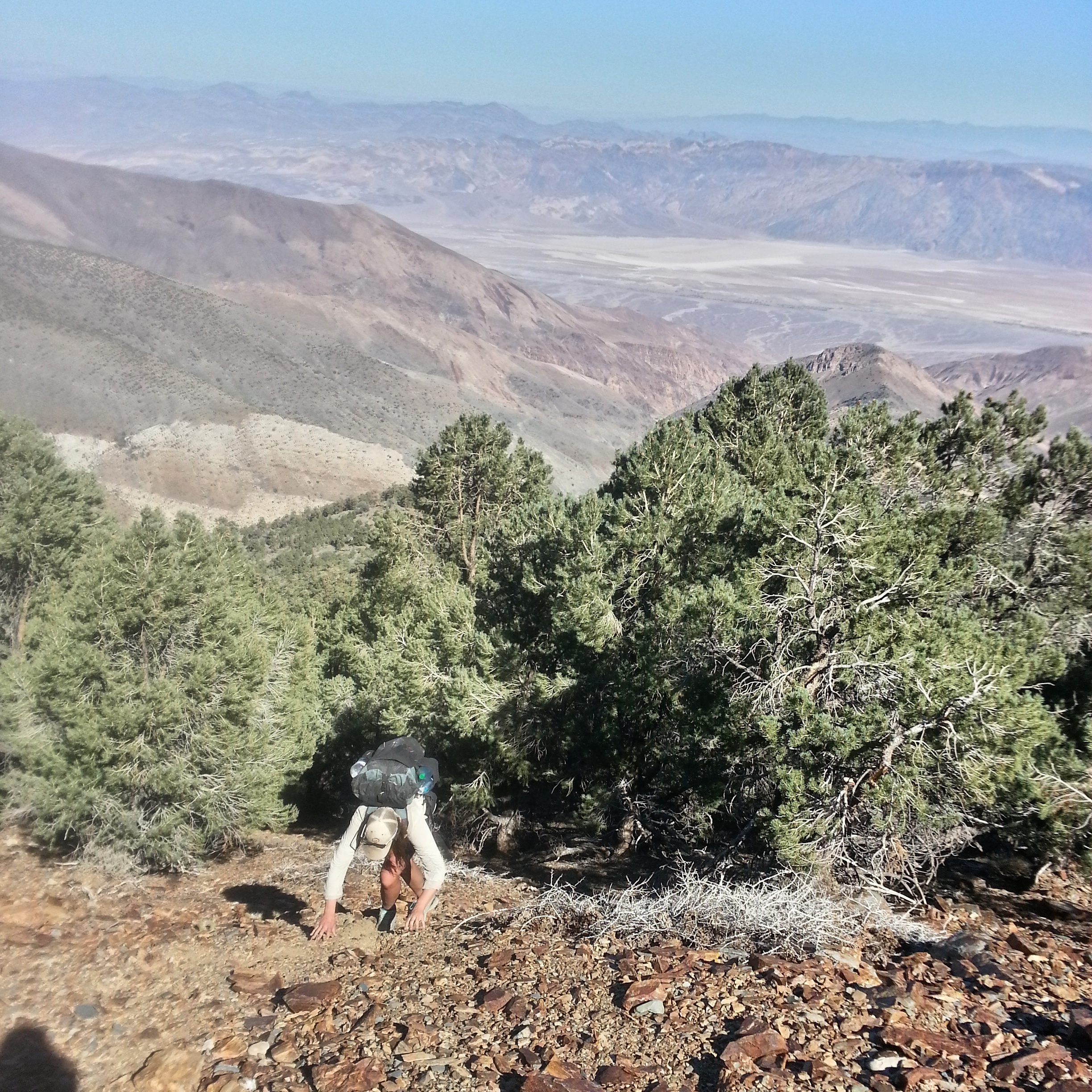
Chance, almost to the top. Way below you can see the salt flats where we started.
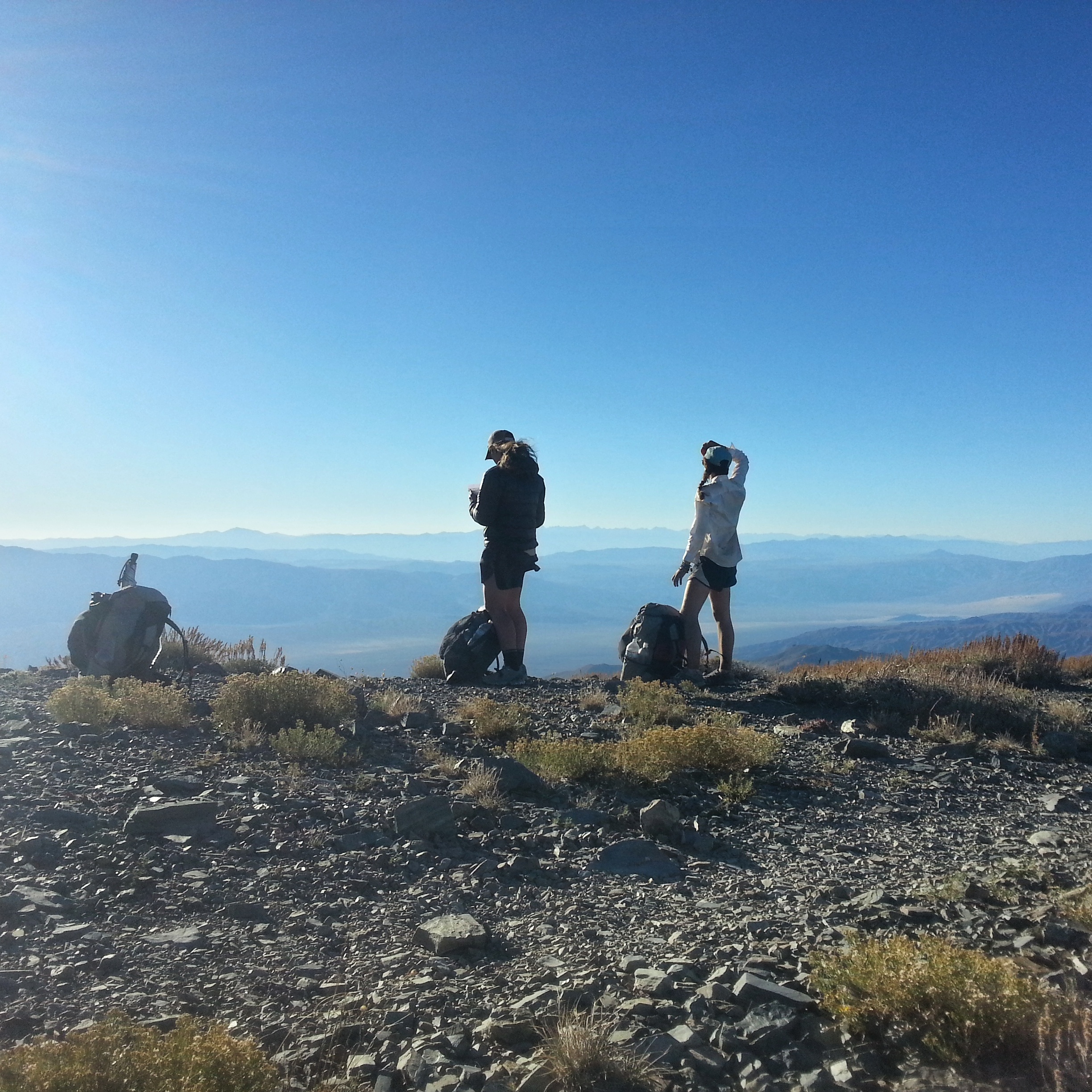
The three of us reach Telescope Ridge at 3 p.m.- the last seven miles of the climb take us five hours. Chance and I are completely busted and we curl up in the sun with our hats over our faces and feign sleep. Jess elects to climb another thousand feet up a side trail to the peak. Jess is one hell of a brilliant hiker- she has a natural talent that’s almost eerie and we joke that it’s just a matter of time before she “goes to the races” and starts her life as a champion ultrarunner. Chance and I will pace her, we say, and help her train, and afterward she’ll use the prize money to take us all to Nepal.
From one side of the ridge we can see Hanaupah Canyon, and the salt flats, and the place where the road is, where we started. On the other side of the ridge we can see where the folds of the mountains peter out into another great, flat, baking valley- that’s what we’ll cross next. I eat some pretzels and sunflower butter, a couple of bars. I’m almost out of water- our next source is at the bottom of this mountain, in Tuber Canyon. Our destination for the night.
On Telescope Ridge
.
Looking back towards Telescope Peak
.

We cross that next
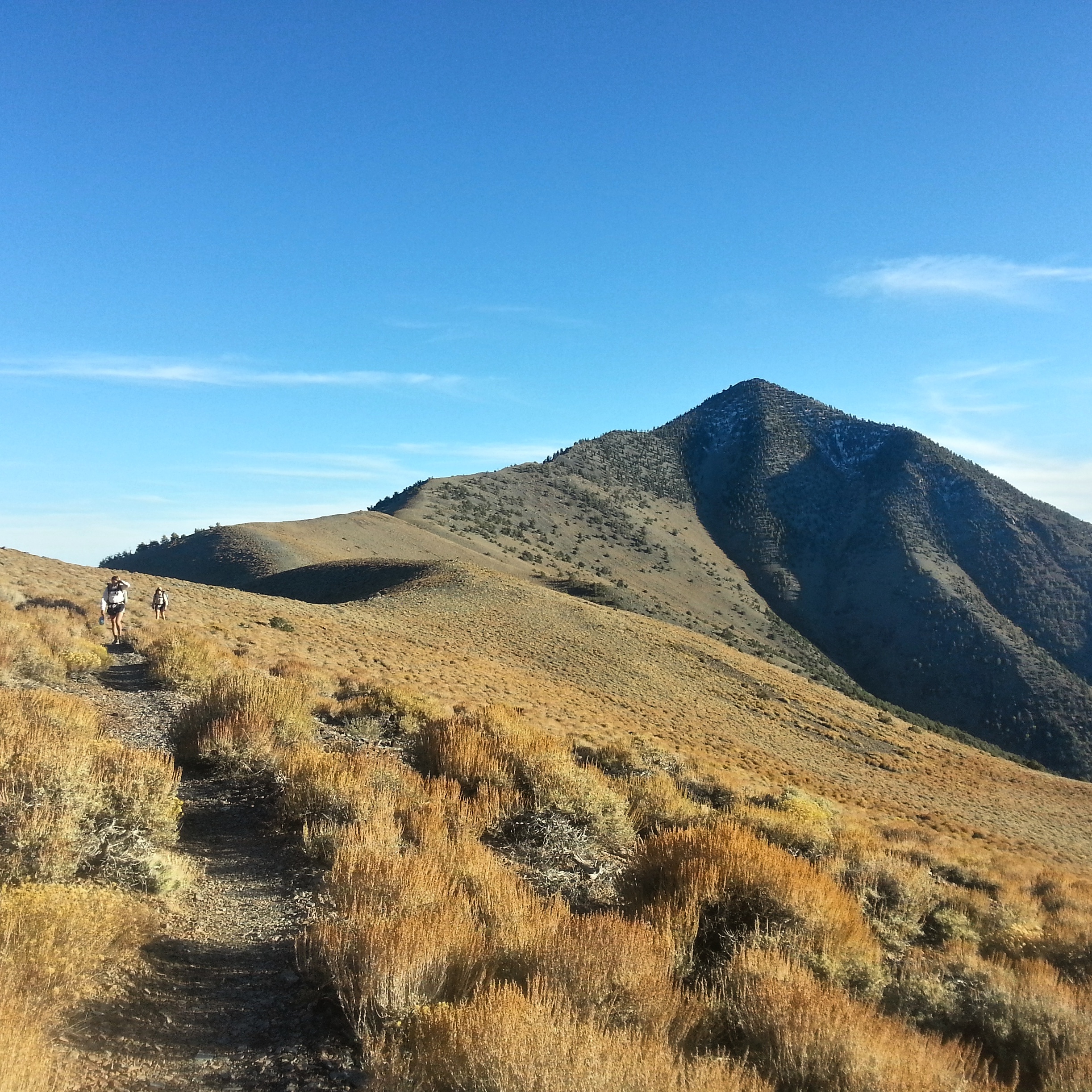
Jess returns (“I’m the first person to sign the summit register since March,” she says) and we make our way across the ridge on two miles of good trail- the only trail we’ll see until the 99 switchbacks up Mt. Whitney on our last day. This actual trail is easy, too easy, and it’s not for us- the trail continues on along the ridge but we leave it to descend overland down a soft, rocky slope towards the valley below, picking our way as quickly as we can the sun sinking in the bright open sky. Then it’s dim pinyon forest, trying to find the right way to go, cutting back and forth among the trees and bushy desert plants, our legs scratched up, just knowing we’ve got to head down, down to Tuber canyon, and water.

Goodnight, sun
It’s dark by the time we reach the canyon, a narrow wash choked with trees and brush. The air is chilled here and there are crickets- you can almost smell the water nearby. I feel certain, though, that we’ve passed the spring- that it’s up the canyon a little ways and that we’ve got to bushwhack backwards a bit to find it. We’ve got a PCT hiker’s aversion to backtracking- on the PCT it is almost always more efficient to go forward as quickly as possible than to backtrack to the watersource, campsite, or whatever it is that you missed. We stand there for a bit, debating- we know that there are several potential springs in Tuber Canyon and we know that Charlie said that at least one of them was running. The one we missed had water, but we don’t want to backtrack. If we keep moving forward, will we find another? We’re thirsty and tired, having blown our entire loads on the climb up Telescope Peak. But we just do not. Want. To backtrack. So here are the possibilities of the known universe-
-There is another spring.
-There isn’t another spring and we hike until two a.m., at which point we reach a road that we can walk another couple of miles to a campground that will have water.
-There isn’t another spring and we hike all night to Panamint Springs Resort, reaching it around dawn.
The first option seems highly unlikely and so we set off, with stupid enthusiasm, into what may turn out to be a very miserable night. I’m thirsty, but not TOO thirsty- this is not my first time at the dehydration rodeo, and I feel that I could comfortably hike until the wee hours without becoming sick. We’re so tired, though, and the wash, although it’s sandy and has opened up a bit, is full of rocks and boulders and it’s slow going in the dark. The three of us stop talking and just sort of hike, scouting around now and then in spots where we think the other potential springs might be. There’s nothing, though, just a whole lot of nothing. It doesn’t seem as though there’s a single drop of water in this whole eerily beautiful, godforsaken place- just the moon, and the rocks, and the slopes of the ridges rising up, and over there a huge clump of big, lush trees-
Trees! The ground around the trees is smooth, trampled dirt, like in a yard where a dog is kept. There are bones and poop everywhere, flat places in the grass. And then Chance is shouting
“Water! I found water!”
And we come running to find a rectangular, shallow depression beneath the low tangled limbs of the trees, dug out by enterprising creatures, and yellow, clear-ish water pooled there. There are things floating in the puddle, muck on the bottom, but we don’t care. We’re elated. Water! We found fucking water! A spring! The place where every creature this side of Telescope Ridge comes to drink!
I fill up my bottle carefully to minimize floaties, and treat it with my steripen (twice). Jess and Chance don’t treat the water at all. I take a long drink and discover that the water tastes absolutely horrible- it’s sulfuric and warm, sort of salty. Hotspring. It’s like I’m drinking a hotspring. I almost can’t stomach it, but I make myself drink a half liter. I remind myself of how thirsty I am.
A moment later we realize that we can hear running water inside the trees, the source of the spring, but there’s absolutely no way to get to it. The limbs of the trees are like an iron prison- and we’re not the first creature that’s tried to reach the water. This desert is crazy! These trees are nuts! Who are they, to keep the spring for themselves like this? We comfort ourselves with more sulfur-water from the puddle and then bed down in front of the mystical, mysterious, water-bearing tree-fortress, in the trampled dirt where every other creature for a hundred miles comes to sleep, and drink, and fight, and fuck. I can almost feel them watching us, from the ridges above- the wild burrows, the bighorn sheep, the mountain lions. Thirsty, en route to their daily drink, and then- fuck! What are those? Humans? What are they doing here and how long until they perish and we can pick their bones clean?
We sit in our sleeping bags, eating what we can of our dinners. We hiked until 9 p.m. today, traversing a humble 23 miles. But they’re most gratifying 23 miles I’ve ever hiked, and slowly I can feel my old attitude about hiking sloughing away, something new growing in its place. This sense of accomplishment, this intimacy with the land, this camaraderie with Chance and Jess, my real human friends in this great empty desert wilderness. I don’t know what I’m doing right now, exactly, but it’s very, very different than what I did on the PCT. This isn’t a “trail”- it’s just an idea that someone made up. A concept. Who’s to say that I can’t come up with my own ideas? Who’s to say that I can’t find some maps someplace, call up the ranger station, link together the existing water sources? What is this great, wild, busted open world? What is even out there?
A single fat mosquito appears just before I drift off to sleep, and bumps against my face. Then another. Of course there are mosquitoes, in the one place where there’s water. Of course. I unstuff my shelter and pull the mesh over my face, but I can still hear them, like tiny, single engine planes. And it’s warm- strangely warm. It’s supposed to be cool in the desert at night. I’m no expert of desert climates, but I did notice a trend during my two rounds on the PCT- a warm desert night usually comes before a heatwave.

Reading your lyrical descriptions of your experiences is almost like reading poetry. I missed that in your absence of writing, but I am glad for the opportunity to continue reading your blog. For next time, the yellow fat under your skin is adipose tissue…it has a better ring to it but bacon fat is an apt description! Look forward to more.
Twotails- thank you!
I remember hanging my head in shame and self-pity when I realized how fast Red Beard and Orbit could walk.
Also, excellent use of the phrase “blowing our loads.”
– Scrub
Scrub- you are hilarious.
Amazingly written as always.
You three women are incredibly lucky to have each other and to be on this incredible journey together (as you know!). Thanks for saving my day with your skillful writing, Carrot.
My hiking experience is pretty much the opposite of yours. I had always bushwacked before hiking the PCT, so being on a “trail” was a novel experience for me. It felt like a hiker super freeway. But I still pulled out my maps habitually to check my position. Old habits die hard I guess.
Once you start hiking cross country it’s hard to stop. Make’s you feel ALIVE! Till you get lost. Then you cry like a baby.What have I done I’m going to die out here. Great FUN!
I love this story. I want more!
Carrot,
this is not just nice and wise, it’s sheer beauty. Period. And before I get off the track writing clumsy love Mails in broken English to you again, only this: Your writing makes me smile, it makes me pause, it makes my heart sing, it makes me think, it makes me dream. Pretty much everything one can wish for from a writer’s work. Thank’s for sharing this.
May there always be enough water and food in your pack and – most of all – love in the air.
Frank aka Longlegs
How about the Hayduke Trail?
Your description of the watering hole is brilliant. I once camped at a spot like that in the Utah desert, and I still feel chills thinking about the eerie energy of that place.
Carrot dear, you are eloquent!
I’ve been to the Telescope Peak area and it was gorgeous!
Enjoy the rest of your sojourn, and be safe…
MORE !!!!!!!
Good to see you hiking and writing!
Thems powerful words”The most gratifying miles I’ve ever hiked”! I absolutely love your description of the cross-country ridge & beyond, and how a whole new world of travel was unfolding under foot! This is what I live for too, and you put it to words so well. I feel one with the land, with hands, feet, breath, senses heightened, navigating, balancing, rushing with endorphins…
Thanks for expressing this Carrot,
Scott
Well done. I tried this route about 5 years back. Those fucking salt flats were a disaster. I had nightmares doing them in the dark and cutting my legs open on the pavement like hardened salt upheavels Thankfully I had a light and a full moon. Somehow I managed to pick the wrong ridgeline and ended up at a mine. So no epic peak bagging. Keep up the awesome work y’all. Off the trail and recouping so living through others adventures.
Might have to give it another go as my route finding skills have improved
Cheers- DC
Carrot, you are my favorite writer. As I grow older, with bad knees, regretting never having done what you continue to do, I feel grateful, happy and even joyful at times for your writing. Thank you for sharing your beautiful life with so many. I feel someday your books will provide you the monetary means to make that trip to Nepa
Carrot, you 3 are crazy brave. epic-ness quotient off the charts. how’s it going?
Carrot are you OK? I’m checking everyday for the end of the story. Cheers
Donna- this hike happened the first week of October- we finished 3 weeks ago. I’m working on the next installment, but have been super busy w work. I’ll get it up in the next couple of days, thanks for reading!
Yeah, I was a little worried, too. Be cool.
Pingback: Lowest to Highest, a Backcountry Route from Badwater to Mt. Whitney, Part Two- Mystical Water Fortresses and an Unbound Freedom I Didn’t Know Existed | CARROT QUINN | Tjamrog's Weblog