8/25
14 miles
We’re at The Hostel California in Bishop, California, getting our things in order, when two young men wander inside and ask if anyone would be willing to portage some gear twelve miles for them, up and over Bishop pass. They’ll be hauling kayaks up for the Kings River, and won’t be able to carry the thirty pounds of other gear that they need. They’ll pay.
We- Kodak and I- are headed up and over Bishop pass today, en route to the Kings Canyon High Basin Route. The KCHBR is a (normally) 124-mile route through the High Sierra. It’s 80% cross-country and has 7k feet of elevation change per 10 miles. The route has been pieced together by Andrew Skurka (learn more about the route here), and usually begins at Lodgepole and finishes at Roads End. We’re hiking it as a 180-mile loop, going in and out at Bishop pass, connecting Roads End and Lodgepole via trails and using Lodgepole as a resupply midway (we hope- the website certainly makes it seem as though there is a large grocery store there).
It takes us an hour to figure out how to strap the kayakers’ gear onto the outsides of our packs, which are already full with eight days of food. Is this a bad idea? Maybe. But it’s also funny, and a fun way to start our hike. And we’re being paid!
A few weeks ago I was finishing up my southbound hike on the PCT’s Washington section. Now I’m here. I’ve wanted to hike the Kings Canyon High Basin Route since I first heard about it, when Andrew Skurka originally published the guide in 2015. I’ve never done anything cross-country in the high sierra, and this route sounded like the perfect introduction- sort of like the Sierra High Route- wildly challenging, slow, and beautiful- but more mysterious, because not as many people have hiked it. I’d resigned myself to doing the route solo, but then I thought to reach out to Kodak, who I’d met on the PCT in Washington and who I knew was in Cascade Locks, stuck behind the fire closures in Oregon. Kodak seemed like just the hella chill spontaneous weirdo that I would want to hike cross-country for days with, and I was stoked when he said yes! to my invitation. Also, my van, Mark, was in Portland, and he could drive it down, which would both bring my gear to me and provide him with transportation south. It’s nice when things all kind of work out, you know?
We finally get our stuff together and are at the trailhead by noon- the kayakers set out a few hours ago. There’s no parking left at the overnight section of the South Lake parking area, so we park my van 1.5 miles down to the hill, near Parcher’s resort. It’s weird to be leaving my van, with all my most important possessions, at this remote trailhead for, how long? We don’t even know. Will we be able to hike twelve miles of this route a day? Less? Is it going to be one mph terrain, mostly? Two mph? I honestly have no idea. There’s not even a line on our maps, just a bunch of dots. There are only a few sentences of notes telling us how to get from each dot to the next. This is the first time I’ve hiked a route that was just a bunch of dots, a path in the wilderness so conceptually free. What will that be like? I don’t know. We huff and puff as we walk up the road towards the trailhead. We’re nearly at ten thousand feet, and climbing. How long will it take us to acclimate?
The sky drops hail as we hike up the trail to Bishop pass, and everything is so beautiful- the rays of light on the granite peaks around us, the water shining off the rocky trail, the clear lakes, that it makes us laugh- what is this? What is this world that we live in? Seven miles later we reach the pass, a collection of granite slabs and residual snowfields, and catch up to our kayaker friends, who are wearing the boats on their backs, and thus look like brightly colored kayaks with legs bobbing down the trail. It’s great. Everything is great!
Kodak has never been to the high sierras before. He’s out of his mind, already, at the beauty of it, which is making it even more fun for me. He’s also never done a cross-country route. That part will start tomorrow- today is entirely on trail.
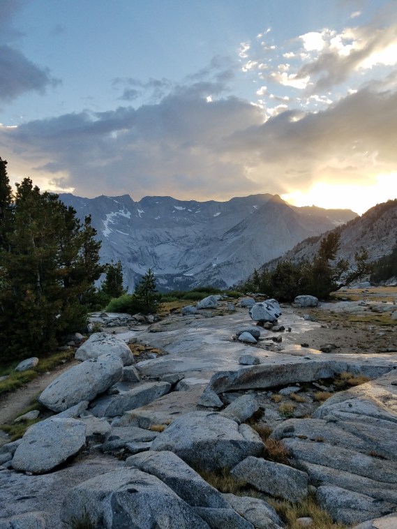
light show
Planet earth treats us to an incredible sunset light show as shades of pink drop from the last of the clouds onto the hazy granite peaks and we reach our campsite, a sweet flat spot in the trees alongside the tight switchbacks down to LeConte Ranger station, after dark. We happily shuck our too-heavy packs, and I remove the kayakers’ dry bag. Tomorrow we’ll be back to regular heavy, with just seven days of food. Relief! I pitch my little shelter against the cold condensation and drift off in my warm fluffy sleeping bag. I get up once to pee, and see some lights on the huge flat slab next to camp. It’s Kodak, taking a long-exposure shot of the milky way. Cool.

You must be logged in to post a comment.